
A nearly century-old snapshot of the London Underground could be yours – that is, if you have £100,000 to spare.
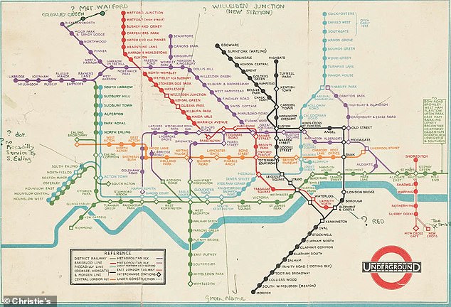
Christie’s is set to auction off a rare 1932 draft of the Tube map created by Harry Beck, an Essex-born electrical draughtsman.
It features hand-written annotations from Beck and Frederick Stingemore, who designed London Underground maps produced between 1926-1932.
Beck created the map while unemployed, shortly after he was laid off by the Underground Electric Railways Company of London.
While initially considered radical, his pioneering approach to the sprawling network set a benchmark for every Tube map officially circulated since.
Christie’s says: ‘Beck abandoned the rules of scale and geometric accuracy to create the iconic and highly influential Underground map.’
Eagle-eyed readers may notice some unfamiliar names, such as Post Office, British Museum, Mark Lane and Bishop’s Road.
So, can you spot the forgotten stations that were given new names or shut for good?
At the time, the Tube consisted of the ‘District Railway’ (green), the Bakerloo Line (red), Piccadilly Line (light blue), Central London Railway (orange), Edgware, Highgate and Morden Line (black) and the Metropolitan Railway (purple), the oldest tube line which opened in 1863, initially just linking Paddington with Farringdon
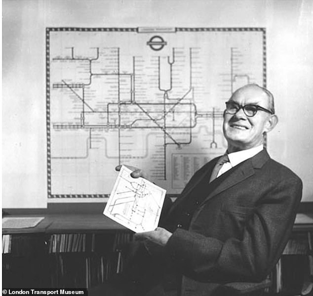
Harry Beck (pictured) made the famous network easier to understand by using only straight lines and 45 degree angles, making use of space for a more digestible layout
The London Underground has its origins in the Metropolitan Railway, which opened January 10, 1863 as the world’s first underground passenger railway.
Before 1932, maps of the Tube had been printed and circulated, but Beck’s effort marked the first ‘diagrammatic’ one that was not geographically accurate.
He’d noticed that geographic maps had meant a lot of detail was bunched together and hard to read – an increasing problem as the Tube expanded.
He made the famous network easier to understand by using only straight lines and 45 degree angles, making use of space for a more digestible layout.
He’s thought to have been influenced by his experience creating schematics for electrical systems, making it resemble an electrical circuit diagram.
The draft is dated to 1932, the year before Beck’s reworked tube map was released to the public, at which point the London tube system had already been in operation for 69 years.
As the 1932 map shows, the Tube at the time consisted of the ‘District Railway’ (green), the Bakerloo Line (red), Piccadilly Line (light blue), Central London Railway (orange), Edgware, Highgate and Morden Line (black).
There’s also the Metropolitan Railway (purple), the oldest tube line which opened in 1863, initially just linking Paddington with Farringdon.
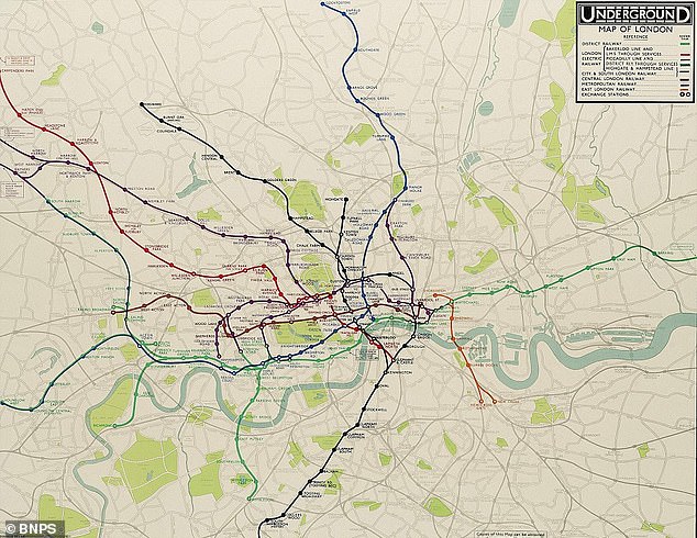
Pictured, one of the final geographical efforts by Frederick Stingemore before Harry Beck’s revolutionary map was used from 1933
There’s also the East London Railway which connected Shoreditch with New Cross on the other side of the Thames, plus other parts ‘under construction’.
Some of the stations no longer in existence include British Museum in Holborn, which closed in 1933 and would become an air raid shelter in WWII, and Brompton Road between Knightsbridge and South Kensington, which closed in 1934.
Another ‘ghost station’ is Mark Lane further east, which was closed in 1967, and Marlborough Road, between St John’s Wood and Swiss Cottage and closed in 1939 (now used as a power station).
Other names that people today might not recognise include Praed Street (later incorporated into Paddington), Strand (now part of Charing Cross) and Addison Road (Kensington Olympia).
Many others were renamed including Queen’s Road (now known as Queensway) Post Office (St Paul’s), Walham Green (Fulham Broadway) and Dover Street (Green Park).
One fondly-remembered station called City Road in Islington was closed 10 years prior to this map and is therefore notably absent.
Another abandoned station which members of the public can visit today as part of London Transport Museum’s guided tours is Down Street, closed in 1932.
Incredibly, Beck’s map was was initially rejected by London Transport’s publicity department because it was considered too radical, but a successful trial print-run showed that it was what the public wanted.
When it closed in 1933, few would have expected that British Museum Underground station (pictured) would be repurposed as air raid shelter
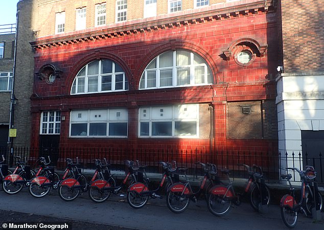
The former Brompton Road station (pictured) was so rarely used, tube drivers would often skip the stop altogether. It closed on July 30, 1934 but the exterior’s handsome red glazed wall tiles can still be seen
‘The result was an instantly clear and comprehensible chart that would become an essential guide to London and a template for transport maps the world over,’ Transport for London says.
Beck’s ‘revolutionary design’ survives to the present day with very slight modifications and additions, such as circles instead of squares to denote interchange stations and names in lower case instead of all-capitals.
Perhaps ironically, Beck’s diagrammatic approach has become so ingrained that modern artists consider themselves radical by creating up-to-date geographical versions.
The rare copy of Beck’s map will be included in Christie’s live auction event ‘Groundbreakers: Icons of our Time‘, which takes place on December 11.
It is expected to fetch £100,000 ($131,000).