

Americans in five states have been warned that they could see tornados form as thunderstorms threaten the South today.
Extreme weather predictions for Friday have revealed a minor risk of twisters in southern Kentucky, Tennessee, Mississippi, Alabama, and small parts of northern Georgia.
Overall, the National Oceanic and Atmospheric Administration (NOAA) called the risk ‘marginal,’ however their forecast still warned that short-lived tornados may touch down in isolated spots.
If tornados do break out, they would most likely be an EF-0 or EF-1, weak twisters that last only a couple of minutes and mainly damage trees and tear shingles off roofs.
Forecasters added that clusters of showers and thunderstorms are expected to roll through the region Friday afternoon, with an even higher likelihood tonight.
Local meteorologists in Mississippi and Alabama have called for heavy rainfall, with thunderstorms continuing throughout the day, and a small chance that the storms turn severe.
Meteorologist Tori Alvarado for WTOK said: ‘The biggest risk being the potential for damaging wind gust, but an isolated tornado cannot be ruled out.’
‘After all of the rain is said and done, we could see anywhere from 1-2 [inches] of rain, but some areas locally could see more.’
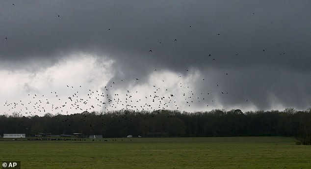
Almost 20 tornadoes rampaged across several Mississippi towns earlier in 2025 (Pictured). Friday’s forecast reveals a marginal risk of twisters forming (Stock Image)
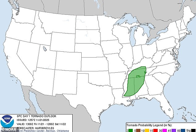
NOAA issued a low-level notice for severe weather in Georgia, Mississippi, Alabama, Tennessee, and Kentucky Friday night
NOAA’s computer models and weather balloon readings showed that the wind right near the ground in these states was blowing pretty fast from the south or southeast.
Just a couple thousand feet up, however, the wind this morning was already much stronger and coming more from the southwest.
This change in speed and direction creates a ‘twist’ or rolling motion in the air. When a thunderstorm’s rising air moves over that twisting layer, it can tilt the spin upright and turn a regular storm into a rotating one.
Friday’s forecast revealed a strong low-level twisting, causing the low-level tornado warning.
Even though the air isn’t hot or unstable like it is during the warmer months of the year, there’s still enough moisture and weak lift from a disturbance moving overhead to create clusters of showers and thunderstorms.
NOAAA believes most of these storms will be too weak and rainy to do much damage, but one or two of them may ‘grab’ that twist in the wind near the ground and spin up a brief tornado.
Moving into the weekend, the storm prediction agency also warned of a higher risk of extreme weather on Sunday across Texas.
From Central Texas down toward the Rio Grande Valley, including cities such as San Antonio, Austin, and Laredo, another round of severe storms are possible starting Sunday night and lasting into Monday.
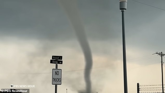
Twisters form when a thunderstorm’s rising warm air grabs hold of twisting winds near the ground and stretches that twist upward into a spinning tube (Stock Image)
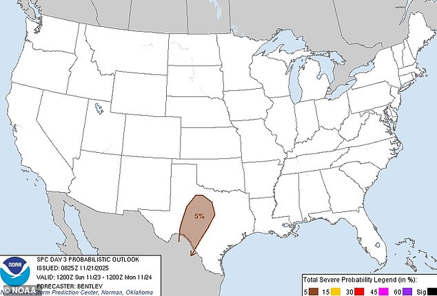
A stronger severe weather notice has been issued for Texas on Sunday, including in cities such as San Antonio, Austin, and Laredo
Although most areas are expected to see normal thunderstorms and rain, a couple of isolated storms could bring down large hail stones the size of a golf ball as the weather turns extreme.
‘As storms grow upscale, the threat for damaging wind gusts will increase during the late evening and into the overnight period,’ NOAA’s Storm Prediction Center added.
Tornados will again be rare and unlikely, but meteorologists can’t rule them completely out of their forecasts.
If any tornado forms, it would probably be another weak and short-lived twister like the ones expected on Friday.
A tornado can last anywhere between a few moments to hours, although the average twister touches down on the ground for roughly five minutes, according to NOAA.
While most Americans have heard of ‘Tornado Alley,’ which stretches across Texas and Oklahoma, there is also a ‘Southern Tornado Alley’ in the Southeast where Friday’s storms are forming.
This active storm belt includes Louisiana, Mississippi, Georgia, Alabama, and the Carolinas.
John Lavin, AccuWeather’s director of forensic services, said: ‘It’s been a particularly bad area for tornadoes over the last 10 years.’