
Tropical Storm Melissa is expected to grow into a major Category 4 hurricane in just days, and the latest tracks warn that it could impact millions along the US East Coast.
The latest spaghetti models for Melissa still show a very uncertain path for the storm, but some of those forecasts warn that the hurricane could make landfall in New York, Massachusetts, or Maine.
The National Hurricane Center has projected that Melissa will reach hurricane status by Saturday and continue to build into a major hurricane with winds over 130 mph by Monday.
It’s currently building in strength in the Caribbean, just south of Jamaica, generating sustained winds of 50 mph.
However, meteorologists have warned that will soon change as the slow-moving tropical storm moves through the warm waters of the Caribbean and wind shears begin to ease this weekend, allowing Melissa to quickly strengthen.
Once the hurricane barrels over the Cuba, one track now shows the hurricane spinning directly towards New York City, while another one warns that Boston could be hit.
AccuWeather Chief Meteorologist Bernie Rayno said: ‘The longer Melissa tracks to the west, the greater the chance of an impact on the US.’
It’s been more than a decade since New York has been directly impacted by a hurricane, when Superstorm Sandy decimated communities along the East Coast in 2012.
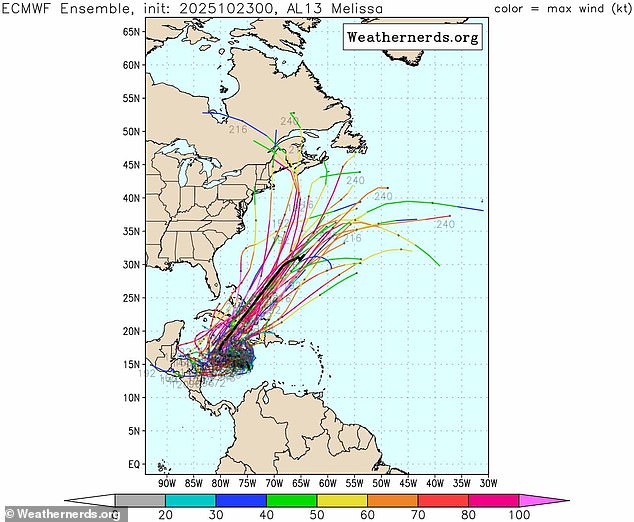
The latest spaghetti models for Melissa show the potential major hurricane making landfall in New York
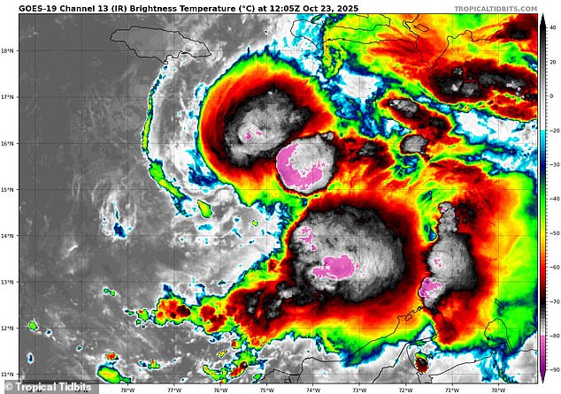
Melissa (pictured on radar) is currently a tropical storm with sustained winds of 50 mph, but is expected to become a Category 4 hurricane by Monday
The spaghetti model showing a possible direct hit in the Northeast relies on data from the European Centre for Medium-Range Weather Forecasts (ECMWF), one of the world’s most accurate forecasting systems.
However, meteorologists cautioned Melissa’s path next week is still very much up in the air and will be heavily influenced by the natural jet stream flowing across the US.
Ben Noll, a meteorologist at The Washington Post, explained that current forecasts show several low-pressure systems forming along the entire East Coast, including several right over New York.
According to Noll, each low-pressure system represents a potential landing spot for Melissa next week.
Low-pressure systems are like the engine that powers hurricanes. They’re areas where the air is rising, which can pull in warm, moist air from the ocean.
This warm air fuels the storm, making it spin and grow stronger, turning into a stronger hurricane if conditions are right.
While Noll and other forecasters believe an East Coast landing is on the table, WPIX senior meteorologist Mike Masco argued that spaghetti models showing Melissa hitting New York shouldn’t be shared on social media.
‘Social media is about to scare the c*** out of you the next 7–10 days with talk that tropical system “Melissa,” now south of Jamaica, will race up the coast and get captured into the East Coast pattern,’ Masco wrote in a post on X.
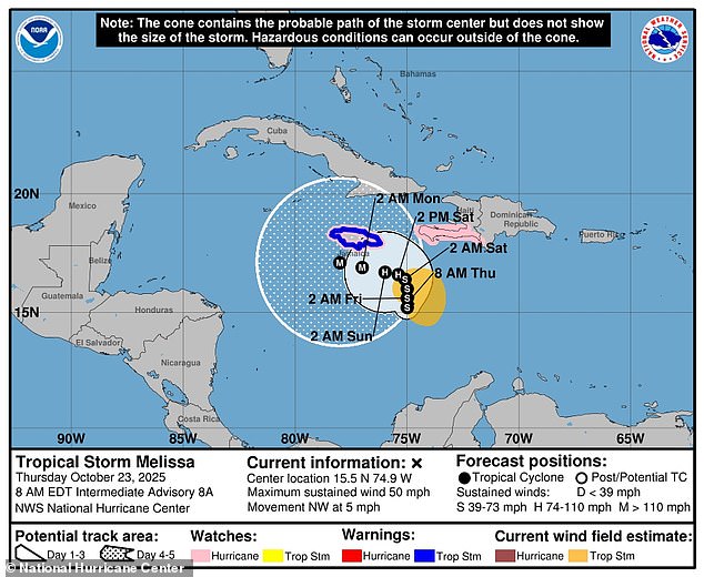
The National Hurricane Center says Melissa will reach hurricane strength as it nears Jamaica and Cuba this weekend
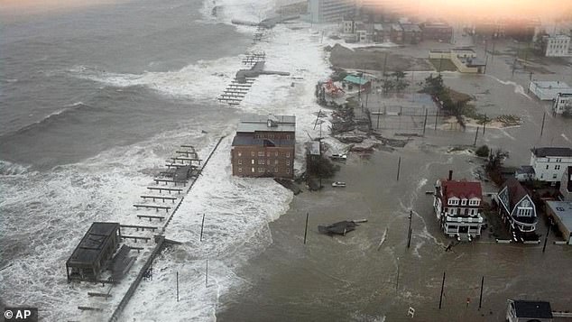
The potential for Melissa to reach New York could make the storm the first major hurricane to impact the state since Superstorm Sandy in 2012 (pictured)
‘While that’s possible and plausible track (in my view), it’s definitely not the most likely or only outcome,’ he continued.
Masco added that the ‘worst-case’ Canadian model for Melissa overemphasizes a high-latitude blocking pattern that could steer the hurricane.
It also assumes there will be a strong jet stream, called the vorticity maximum or ‘vort max,’ that might not develop as predicted, leading to an unrealistic track towards the Northeast.
AccuWeather meteorologists added that it’s more likely to go further east into the Atlantic because steering winds from the US jet stream are expected to guide Melissa northward, avoiding a direct hit on the East Coast.
AccuWeather lead hurricane expert Alex DaSilva noted: ‘The chances of a direct US hit from Melissa are low right now, but it is still an option, should the tropical system make it into the western Caribbean.’
Short-range forecasts within one to three days are considered highly reliable, while projections beyond seven to 10 days grow increasingly uncertain.
Most current ECMWF tracks show Melissa staying well away from the US in the near term. But some longer-range runs suggest possible paths up the East Coast toward the end of October and into early November.