
A chilling new report has revealed that vast stretches of the US, including major cities, are sitting in disaster danger zones.
FEMA released its latest National Risk Index, which analyzed decades of disaster data, weather patterns, and population vulnerability.
The report ranked every county and neighborhood by its exposure to 18 natural threats, from hurricanes and wildfires to flash floods and heatwaves.
At the top of the list, officials identified California, Florida, and anywhere on the US coast.
These states face overlapping threats, including rising sea levels, powerful hurricanes, and extreme heat.
The same goes for regions in Washington, Oregon, and Nevada.
Meanwhile, New England emerged as the safest region in the country, with Vermont, New Hampshire and Rhode Island having nearly all neighborhoods ranked low risk.
Pittsburgh, Pennsylvania, stood out as the safest major US city, with no moderate or high-risk zones.
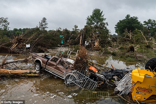
In early July, flash floods killed at least 135 people in Texas after more than 20 inches of heavy rainfall in 72 hours
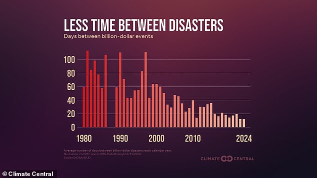
In 2024, the US averaged one billion-dollar weather disaster every 12 days, compared to once every 60 days in the 1980s
The disaster risk map showed more than just high-risk or safe places, it also reported the socially vulnerable zones, which included factors like poverty, housing quality, and recovery plans for disaster.
Southern California counties like Los Angeles and San Bernardino were marked as the highest risk areas. The state has seen more than 120,000 wildfires since 2000, burning over 12 million acres.
FEMA has declared 39 major disasters in California since 2010, many of them wildfires fueled by extreme drought, dry winds, and growing development in fire-prone areas.
Experts said California is good at emergency response, but its crowded cities and dry land make recovery harder and slower.
Florida was also mentioned as a high risk zone as it faces more hurricanes than any other state annually. Last year, Hurricane Idalia caused over $3.6 billion in damages alone.
According to the National Ocean and Atmospheric Administration (NOAA), about 23 million people in the US now live in areas at high risk of flooding.
Rising seas are making hurricanes worse, as the sea levels have risen in some parts of Florida by as much as eight inches since 1950.
Other high-risk zones include coastal parts of Louisiana, Texas, Georgia, and the Carolinas. These places are often struck by either severe storms or floods.

At the top of the list, officials identified California , Florida , and anywhere on the US coast
FEMA records showed many counties along the Gulf and Atlantic coasts have had 10 or more disaster declarations in the last 15 years.
Recent data from Climate Central also revealed that in 2024, the US averaged one billion-dollar weather disaster every 12 days, compared to once every 60 days in the 1980s.
Flash floods alone have doubled compared to the 10-year record, with more than 4,800 events reported this summer across places from the scorched hills of New Mexico to small towns in Central Texas.
Meteorologists said it is because warmer air holds more moisture, and when storms hit, they dump more rain at faster rates.
The FEMA map showed cities in Texas like Austin and San Antonio were relatively high risk because of crowded neighborhoods and poor drainage.
In contrast, Pittsburgh, Pennsylvania was the lowest-risk big city in the country. Since it is far from the coast, has a mild climate, and updated infrastructure, their risk for severe storm damage is low.
Many of the safest states, like Vermont, New Hampshire, Rhode Island, and parts of Ohio, had fewer disasters and less severe weather annually. All had more stable infrastructure over the past 30 years.
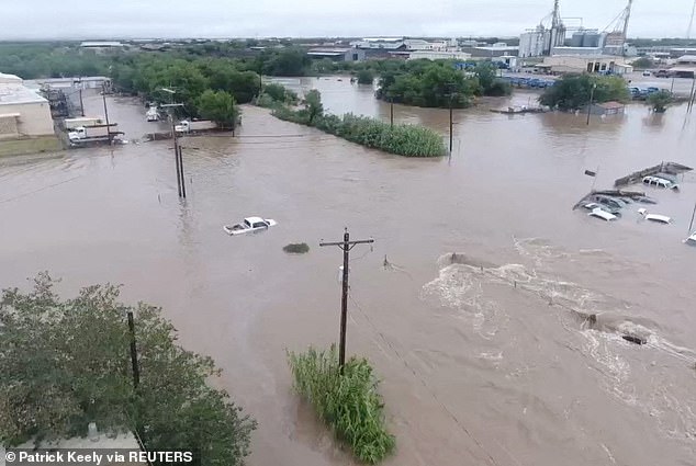
Over 100 people were killed in early July when devastating flash floods tore through Central Texas
According to FEMA’s historical declarations, Vermont was the safest state overall and rarely sees disasters because of its natural landscape, including mountains and forests, which help absorb more rainfall faster.
New Hampshire and Rhode Island have similar advantages, as both states sit inland or on rocky coastlines which make them less exposed to hurricanes.
Ohio ranked low in nearly every FEMA risk category. It rarely sees hurricanes, wildfires, or earthquakes. Most weather events there are mild. Its flat land also reduces the risk of landslides and flash floods.
Even Charlotte, a city in hurricane-prone North Carolina, scored low on FEMA’s scale. Its inland location shields it from coastal damage, and strong city planning has helped reduce risks tied to flooding and power outages.
Still, experts with FEMA warned that no area is immune to extreme weather events and Americans should treat this map as a planning tool, not a guarantee.
Michael Oppenheimer, a climate scientist at Princeton University, said: ‘What happens with climate change is that what used to be extreme becomes average, typical, and what used to never occur in a human lifetime or maybe even in a thousand years becomes the new extreme.’
‘We start to experience things that just basically never happened before,’ he warned.