
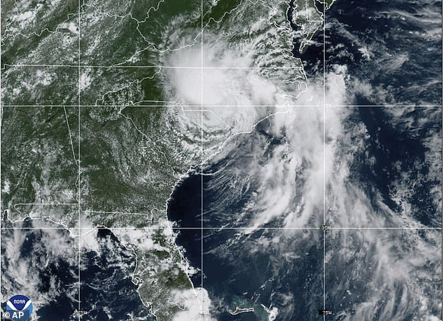
Millions of Americans are under flood alerts as a storm moves northward along the East Coast, bringing heavy rain, dangerous surf and widespread power outages.
Chantal made landfall in South Carolina as a tropical storm but has since weakened to a tropical depression after losing strength over land.
However, the National Hurricane Center (NHC) warned it still poses a threat of tropical storm conditions to millions this week.
More than 17,000 residents in Orange and Chatham counties remain without power due to downed trees and power lines.
As Chantal pushes into Virginia on Monday, forecasters expect up to four inches of additional rain, raising concerns about flash flooding in low-lying areas.
Flood watches are also in effect across parts of Delaware, New Jersey, Pennsylvania, and Maryland, where heavy rain is forecast to continue into early this week.
Life-threatening rip currents are expected along beaches from northeastern Florida to the Mid-Atlantic, with officials urging beachgoers to avoid entering the water.
Millions of Americans are under flood alerts a storm moves northward along the East Coast, bringing heavy rain, dangerous surf and widespread power outages

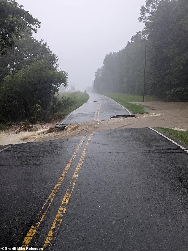
The storm unleashed up to 10 inches of rain across central North Carolina on Sunday (pictured), inundating homes, submerging roads and stranding numerous drivers
‘Tropical Depression Chantal will continue to produce heavy rainfall across portions of northern North Carolina and Virginia into Monday,’ the NHC shared in a Monday morning update.
‘Storm total rainfall of 3 to 6 inches, with local amounts up to 9 inches, is expected. An elevated risk for flash flooding will continue.’
A tropical storm is a weather system with sustained winds ranging from 39 to 73 miles per hour, capable of producing heavy rain and causing significant damage.
A tropical depression is weaker, with winds below 39 miles per hour, but it can still bring heavy rainfall and flooding. Both require close monitoring due to their potential impacts.
‘Residents in flood-prone or low-lying areas should move to higher ground immediately. Do not wait,’ the alert added.
In response to rising waters, Orange County, North Carolina, which includes Chapel Hill, declared a state of emergency Sunday night.
‘Residents in flood-prone or low-lying areas should move to higher ground immediately. Do not wait,’ the NHC urged.
The county warned on social media that ‘numerous water rescues and evacuations are underway in low-lying areas.’

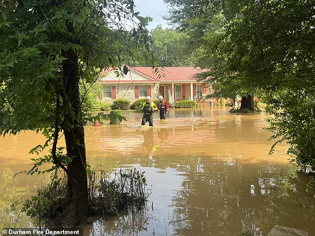
Around 80 people in Durham (pictured) were also rescued by boat, and dozens more were evacuated on foot
More than 17,000 residents in Orange and Chatham (pictured) counties remain without power due to downed trees and power lines
Firefighters in Chapel Hill conducted more than 50 water rescues from Sunday evening into early Monday, with over 60 residents forced to evacuate their homes, the city announced.
Around 80 people in Durham were also rescued by boat, and dozens more were evacuated on foot.
‘Dozens of apartments and homes had to be evacuated as the water level began to reach the tops of vehicles,’ Durham fire officials said in a Monday morning news release.
Water levels at the Eno River rose to their highest point with an increase of 25.63 feet, which qualifies as major flooding, according to the National Oceanic and Atmospheric Administration (NOAA).
Frank Pereira, a meteorologist with the National Weather Service, told the New York Times, ‘While things will improve across North Carolina, they may worsen for areas further to the northeast.’
‘We’re advising people not to go out and travel unless absolutely necessary.’
Areas around Raleigh, North Carolina, are under flood warning until Wednesday morning.

‘Dozens of apartments and homes had to be evacuated as the water level began to reach the tops of vehicles,’ Durham fire officials said in a Monday morning news release
Water levels at the Eno River rose to their highest point with an increase of 25.63 feet, which qualifies as major flooding
As of 5am ET Monday, Tropical Depression Chantal was located about 70 miles east-northeast of Danville, Virginia. Meanwhile, parts of southern New Jersey and Delaware are under flood watches as of 10am.
‘The remnants of Chantal will move into the Mid-Atlantic this morning, bringing heavy rain,’ the NWS said Monday.
‘The tropical airmass will bring generally 1 to 2 inches of rainfall across the urban corridor, with isolated amounts up to 5 inches possible, leading to flash flooding.’
Showers and thunderstorms are expected to end by 8 p.m. ET, with any lingering flooding anticipated to subside overnight.
Chantal’s arrival follows devastating flash floods in Texas, where at least 82 people have died and dozens remain missing after an unprecedented downpour overwhelmed thousands of residents.
The NWS issued a series of flash flood warnings early Friday, escalating to rare flash flood emergencies, alerts indicating imminent danger.
An initial flood watch was issued Thursday afternoon, predicting 5 to 7 inches of rain.
Messaging from the NWS intensified overnight, urging residents to evacuate flood-prone areas and seek higher ground.

Chantal’s arrival follows devastating flash floods in Texas (pictured), where at least 82 people have died and dozens remain missing after an unprecedented downpour overwhelmed thousands of residents
At 4:03am Friday, the agency issued an urgent warning highlighting the potential for catastrophic damage and severe threats to human life.
Local officials said they were unprepared for the scale of the downpour, which dumped what amounted to months’ worth of rain in a short period.
US Secretary of Homeland Security Kristi Noem acknowledged the challenges forecasters face in predicting extreme rainfall.
She emphasized the Trump administration’s commitment to upgrading National Weather Service technology to improve warning times.
‘We know that everyone wants more warning time, and that’s why we’re working to upgrade the technology that’s been neglected for far too long to make sure families have as much advance notice as possible,’ Noem said during a press conference with state and federal leaders.