

Alaska‘s Mount Spurr has experienced 66 earthquakes in the last week, signaling ‘an elevated level of unrest.’
The Alaska Volcano Observatory (AVO) issued an update Friday, saying that the 11,000-foot-tall volcano has a lower level of erupting than it reported earlier in the year.
In March, AVO sounded the alarm that Mount Spurr could blow in the next few weeks, but ground deformation has slowed over the last month, and the shoreline along the crater has not lost ice as it would if magma were rising to the surface.
‘The likelihood of an eruption has decreased from March, but the volcano remains at an elevated level of unrest and an explosive eruption (or eruptions) like those that occurred in 1953 and 1992 is still possible,’ the AVO shared in the update.
‘We would expect to see weeks or more of more elevated unrest that would provide advance warning of an eruption.’
Mount Spurr is located about 78 miles from Anchorage that is home to nearly 300,000 people preparing for the eruption.
Locals have rushed to stock up on food and protective gear in the event the volcano blows without notice.
If the eruption does happen, the event would spew multiple plumes of ash rising as high as 50,000 feet into the air, Matt Haney, scientist-in-charge at the AVO at US Geological Survey (USGS) told DailyMail.com.
Each ash-producing explosive episode would last three to four hours, and the resulting cloud could blanket the city of Anchorage and other nearby communities in a thick layer of dust.
This is a developing story… More updates to come.
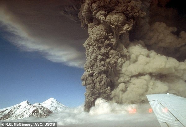
Officials said that when the eruption happens it will be similar to the event in 1992 (pictured)
The eruption would also produce destructive mudslides and avalanches of volcanic debris racing down the volcano’s side at over 200 miles per hour, ‘but fortunately, there are not any communities in that radius that would be affected,’ Haney said.
While AVO said the likelihood of an eruption has decreased, the number of earthquakes has remained consistent throughout April.
The seismic activity is due to magma rising to the surface, causing stress and cracking in the surrounding rock.
AVO conducted two flights to the volcano this week, with one on April 23 that was unable to measure gas emission due to high winds.
But the flight on Wednesday allowed the crew to check Mount Spurr, finding steam coming from vents near the summit and crater lake.
‘No significant surface changes were observed at Crater Peak,’ the AVO said.
‘Gas data from the flight are still being processed, but emission rates appear broadly similar to or slightly lower than those measured in March.’
The updated also noted that sulfur dioxide emissions were detected in satellite data on April 19, 21 and 22.
Sulfur dioxide is released from magma, which suggests the molten rock is still pushing toward the surface.
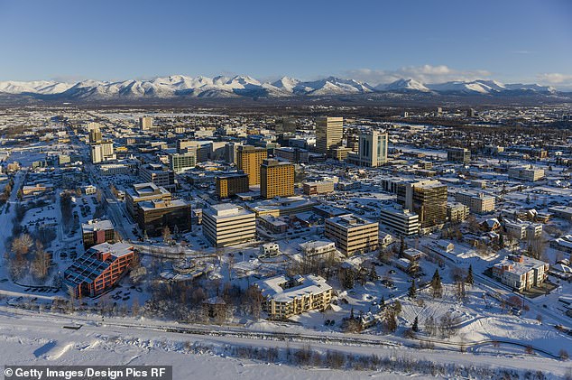
Mount Spurr is located about 78 miles from Anchorage that is home to nearly 300,000 people preparing for the eruption
AVO noted that ‘steaming from the summit continues to be visible in web camera images during periods of clear viewing conditions.’
‘AVO continues to closely monitor activity at Mount Spurr for signals indicating the volcano is moving closer to an eruption using local seismic, infrasound, and GNSS (GPS) stations, web cameras, airborne and satellite gas measurements, regional infrasound, lightning networks, and satellite images,’ the agency shared.
While the likelihood of an eruption without additional warning is currently low, the volcano poses hazards for recreators on Mount Spurr.
That is due to elevated carbon and sulfur dioxide levels in low-lying areas around or downwind of the gas vents, such as within the craters atop Crater Peak and Spurr summit. The AVO noted this is not present in local communities.
The agency predicts the eruption will be similar to those in 1953 and 1992, which saw, ‘one or more explosive events, each lasting as long as a few hours, would produce ash clouds carried downwind for hundreds of miles and minor (up to about ¼ inch) ashfall over southcentral Alaska.’


