

Africa is separating into two – and the split likely started tens of millions of years ago, according to a new study.
By studying magnetic data, scientists at Keele University have discovered evidence of a geological separation starting between Africa and Arabia.
These two landmasses were once connected like two pieces of a jigsaw, but a gradual separation event pulled them apart.
And the separation is ripping through Africa from the north east to the south, like the zip on a jacket, accompanied by volcanism and seismic activity.
By the time the split is complete, perhaps five to 10 million years from now, Africa will be made up of two landmasses.
There will be the larger landmass in the west featuring most African countries, such as Egypt, Algeria, Nigeria, Ghana and Nambia.
Meanwhile, the smaller landmass to the east will include Somalia, Kenya, Tanzania, Mozambique and a large portion of Ethiopia.
‘These findings give a unique perspective on how our planet is constantly changing and shifting right beneath our feet, said Professor Peter Styles, geologist at Keele University.
The old data from the Afar region has been digitised and integrated it with additional “vintage” magnetic data from the Red Sea and Gulf of Aden regions
The theory of plate tectonics tells us that the present configuration of the continents has been very different over geological time.
Millions or perhaps billions of years ago, much larger tectonic plates fragmented and moved apart, creating new oceanic crust and the oceans we now recognise – a process called seafloor spreading.
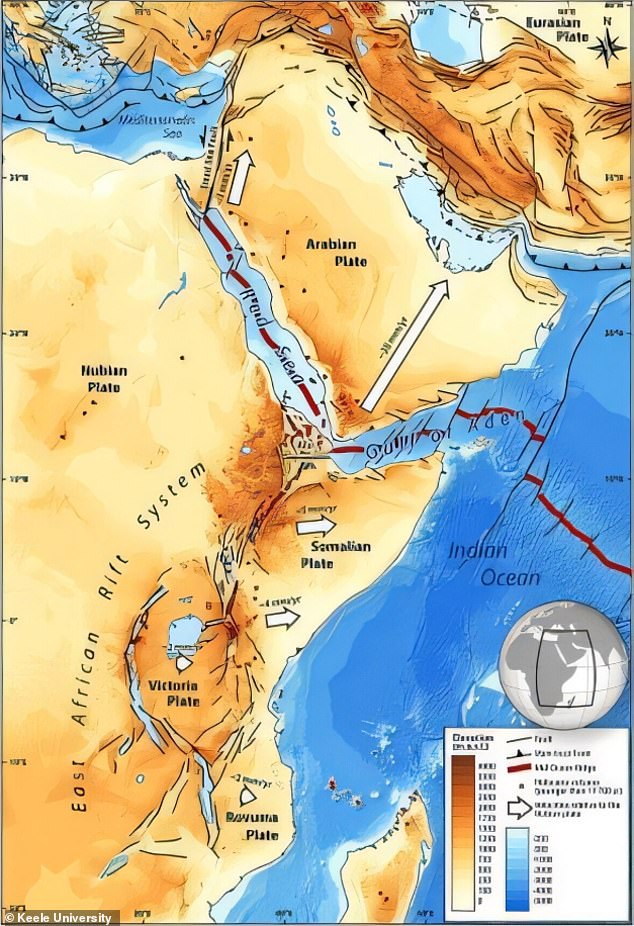
The researchers point to the East African Rift, one of the great tectonic features of Africa, caused by fracturing of the Earth’s crust.
Around 4,000 miles long and averaging 30-40 miles wide, the system extends from Jordan in southwestern Asia southward through eastern Africa to Mozambique.
It’s thought that when Africa separates over millions of years, the gap will run down the length of this rift, splitting through the middle of enormous bodies of water in East Africa, such as Lake Malawi and Lake Turkana.
For this study, the researchers focused on a study area nearer the top of the rift called the Afar region, where the Red Sea meets the Gulf of Aden.
The Afar region is a rare place on Earth where three tectonic rifts meet – the Main Ethiopian Rift, the Red Sea Rift, and the Gulf of Aden Rift – together known as a triple junction.
Scientists believe we are seeing the earliest stages of the spitting process in this area, and it has long been considered that it is occurring or has already.
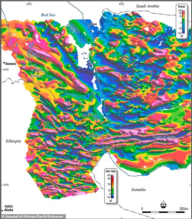
Analysis of the magnetic data showed that seafloor spreading stripes lines run from east in the Gulf of Aden, westwards across and down into the Afar Depression
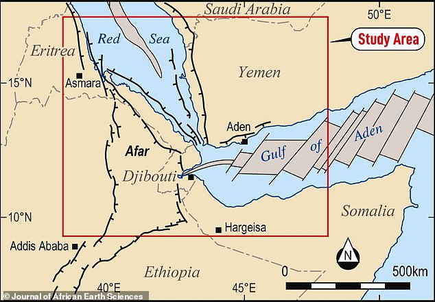
The researchers focused on a study area nearer the top of the rift called the Afar region, where the Red Sea meets the Gulf of Aden. The high-resolution aeromagnetic survey was conducted over the Afar region of Ethiopia, what is now Eritrea
The experts studied magnetic data collected in 1968 and 1969 using airborne instruments to learn more about how the continent of Africa is stretching and splitting.
By combining the ‘vintage’ datasets and using modern technology to analyse them, the team found new insights about the magnetic field of the crust.
Namely, the team used data from scanners that looked at the magnetic profile of the crust that’s formed at underwater mountains (known by geologists as mid-ocean ridges).
When the Earth’s magnetic poles flip – an event that happens once every several thousands or millions of years – it leaves a magnetic mark in the crust that’s akin to a tree ring or the barcode on a supermarket product.
The analysis showed that ancient seafloor spreading stripes run between Africa and Arabia – suggesting the region started separating tens of millions of years ago.
The strong magnetic signature here appears to be evidence of slow but continuous continental rifting – where the crust is being stretched and thinned like soft plasticine – until it ruptures, marking the birth of a new ocean.
While we may imagine the land being ripped apart before our eyes during such an event, will of course be so slow that humans would not notice.
Dr Emma Watts, a geochemist at Swansea University, said the African split is happening now but at a slow rate – 5-16 mm per year – in the north of the rift.
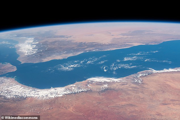
The Gulf of Aden (pictured) is a relatively narrow body of water separating Africa in the south and Yemen in the north – and this is where the split has already begun
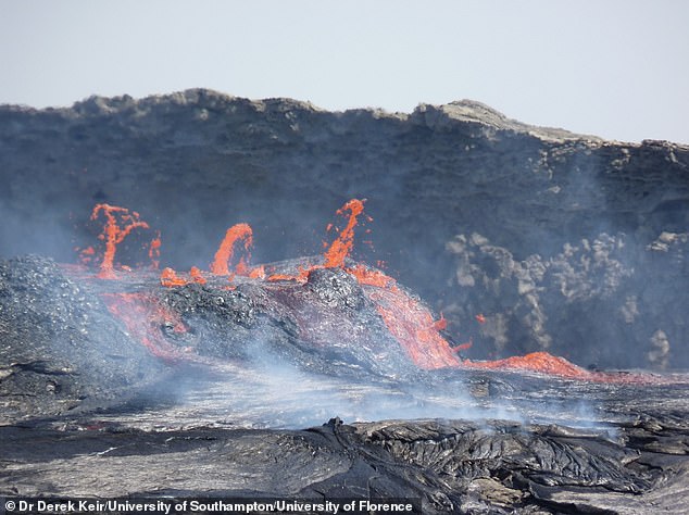
Scientists say a massive crack has started ripping through Africa, from the north east to the south, starting at the Afar region in Ethiopia. Pictured, active lava flows spilling out of the Erta Ale volcano in Afar, Ethiopia
‘Regarding timescales, this process of Africa being torn apart will take several million years before it is completed,’ Dr Watts, who was not involved with this study, previously told the Daily Mail.
The full findings, published in the Journal of African Earth Sciences, reveal more about the ‘complex and fascinating’ Afar region, authors say.
‘With this publication, the magnetic data from the 1968 Afar Survey has been resurrected, we hope, from an undeserved obscurity,’ they conclude.
‘These techniques, in a further paper, will help define the geological evolution of this critically important region for understanding continental break-up and the earliest stages of ocean development.’
The Earth is moving under our feet: Tectonic plates move through the mantle and produce Earthquakes as they scrape against each other
Tectonic plates are composed of Earth’s crust and the uppermost portion of the mantle.
Below is the asthenosphere: the warm, viscous conveyor belt of rock on which tectonic plates ride.
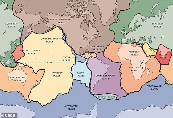
The Earth has fifteen tectonic plates (pictured) that together have moulded the shape of the landscape we see around us today
Earthquakes typically occur at the boundaries of tectonic plates, where one plate dips below another, thrusts another upward, or where plate edges scrape alongside each other.
Earthquakes rarely occur in the middle of plates, but they can happen when ancient faults or rifts far below the surface reactivate.
These areas are relatively weak compared to the surrounding plate, and can easily slip and cause an earthquake.