
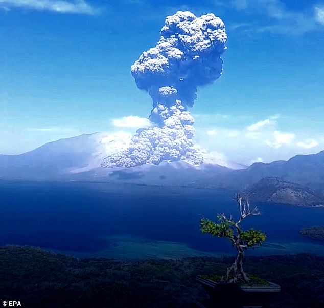
Indonesia‘s rumbling Mount Lewotobi Laki Laki, a 5,197ft-high volcano on the tourist island of Flores, has erupted yet again this morning.
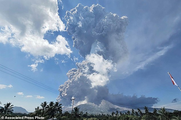
In astonishing new footage, the giant volcano spews a toxic column of ash measuring around 63,000 feet into the sky.
Locals filmed the billowing cloud from a distance – as an official issues an urgent warning for people to stay away.
The cloud has deposited ash on villages, forcing the evacuation of dozens of residents and cancelling several flights.
Volcanic clouds are made up of fine fragments of rock, mineral crystals, volcanic glass and gas, which is mostly harmless water vapour.
However, significant amounts of potentially hazardous gases can be released too, including carbon dioxide, sulfur dioxide and hydrogen sulfide.
Muhammad Wafid, head of Indonesia’s geology agency, said the activity level at the volcano is ‘very high, marked by explosive eruptions and continuous tremors’.
He also urged residents to stay at least 3.7 miles (6 km) away from the volcano and to wear face masks to protect themselves from volcanic ash.
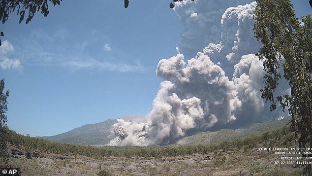
In photo released by Geological Agency (Badan Geologi) of the Indonesia’s Ministry of Energy and Mineral Resources, Mount Lewotobi Laki-Laki spews volcanic materials during an eruption in East Flores, Indonesia, Monday, July 7, 2025
The huge billowing volcanic cloud has deposited ash on villages, forcing the evacuation of dozens of residents and cancelling several flights
Lewotobi is a twin volcano in the southeastern part of the island of Flores, Indonesia with two peaks, called Lewotobi Laki-laki (‘male’) and Lewotobi Perempuan (‘female’).
Lewotobi Laki-laki, which is the more active of the two, is about 1.3 miles (2.1 km) northwest of the taller Lewotobi Perempuan.
Mount Lewotobi Laki-Laki erupted on Monday at 11:05 am local time (03:05 GMT), Indonesia’s volcanology agency said in a statement.
‘An eruption of Lewotobi Laki-Laki volcano occurred… with the observed ash column height reaching approximately 18,000 m above the summit,’ the agency said.
‘This eruption was accompanied by a strong booming sound and hot clouds with a maximum glide distance of 5 km [3 miles] to the north and northeast.’
Fortunately, there have been no immediate reports of damages or casualties.
But the agency warned of the possibility of hazardous lahar floods, which are known to be especially extremely destructive and deadly if heavy rain occurs.
This mixture of water and rock fragments flows down the slopes of a volcano and typically enters a river valley, which poses a hazard for nearby communities.
Mount Lewotobi Laki-Laki erupted on Monday at 11:05 am local time (03:05 GMT), Indonesia’s volcanology agency said in a statement
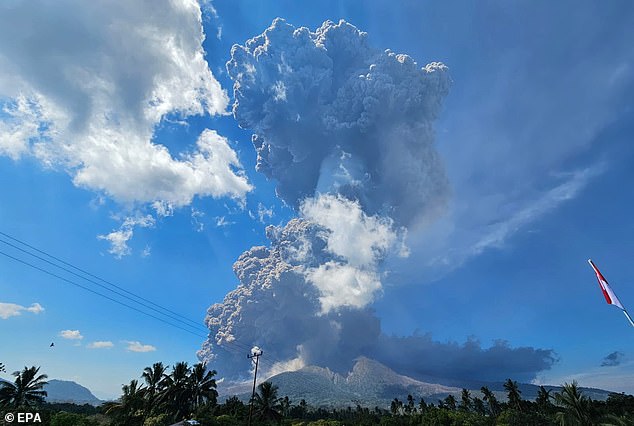
Lewotobi is a twin volcano in the southeastern part of the island of Flores, Indonesia with two peaks, called Lewotobi Laki-laki (‘male’) and Lewotobi Perempuan (‘female’)
A handout photo made available by Indonesia’s Volcanology and Geological Hazard Mitigation Center (PVMBG) shows Mount Lewitobi Lake-laki spewing ash during its eruption in East Flores, Indonesia, July 7, 2025
Several flights from Australia to Bali, a province of Indonesia and popular tourist destination for Australians, have been cancelled, ABC reports.
Affected carriers include Qantas and Virgin Australia and further delays on Tuesday are possible depending on the movement of the ash cloud through the night, it adds.
A customer service agent of airport operator InJourney Airports told AFP that Bali’s Ngurah Rai international airport was still operating normally despite the eruption, but Indonesia’s transport ministry and airport operator did not immediately respond to a request for comment.
Activity has been ongoing at Lewotobi Laki-laki for the last few months; in June, dozens of flights to and from Bali were cancelled after the volcano erupted.
Volcanic ash rained down on several communities around the volcano and forced the evacuation of at least one village.
Mount Lewotobi Laki-Laki erupted multiple times in November, killing nine people and forcing thousands to evacuate, as well as the cancellation of scores of international flights to Bali.
Monday´s eruption was one of Indonesia´s largest volcano eruptions since 2010 when Mount Merapi, the country´s most volatile volcano, erupted on the densely populated island of Java.
The eruption 15 years ago killed 353 people and forced over 350,000 people to evacuate affected areas.
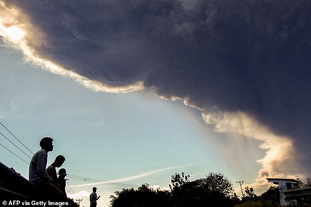
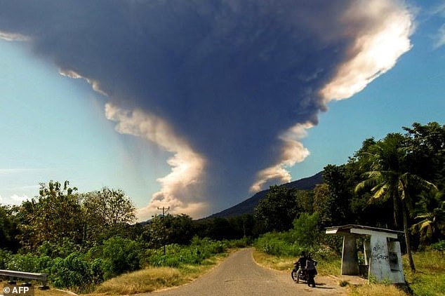
Villagers observe Mount Lewotobi Laki-laki as it erupts, as seen from Nangahale village in Sikka, East Nusa Tenggara on July 7, 2025
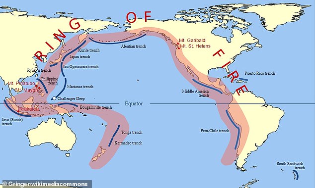
Somewhere between 80 to 90 per cent of the world’s earthquakes occur along an area commonly known as the ‘Ring of Fire’
Indonesia, north of Australia, is a vast archipelago nation of more than 280 million people with frequent seismic activity.
It is positioned at the boundary of three major tectonic plates – Indian-Australian, Eurasian and Pacific – making it prone to earthquakes.
It has 120 active volcanoes and sits along the ‘Ring of Fire’, a horseshoe-shaped series of seismic fault lines encircling the Pacific Basin.
Somewhere between 80 to 90 per cent of the world’s earthquakes occur along the Ring of Fire, which also spans the eastern US coast, Japan and New Zealand.
The Earth is moving under our feet: Tectonic plates move through the mantle and produce Earthquakes as they scrape against each other
Tectonic plates are composed of Earth’s crust and the uppermost portion of the mantle.
Below is the asthenosphere: the warm, viscous conveyor belt of rock on which tectonic plates ride.
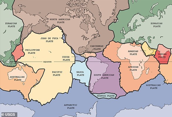
The Earth has fifteen tectonic plates (pictured) that together have moulded the shape of the landscape we see around us today
Earthquakes typically occur at the boundaries of tectonic plates, where one plate dips below another, thrusts another upward, or where plate edges scrape alongside each other.
Earthquakes rarely occur in the middle of plates, but they can happen when ancient faults or rifts far below the surface reactivate.
These areas are relatively weak compared to the surrounding plate, and can easily slip and cause an earthquake.