
A blast of Arctic air is set to sweep across the eastern half of the US starting tomorrow, sending temperatures 15 to 25 degrees below the historical average.
Meteorologists warned Friday that over 100 million Americans will be affected, beginning in the Plains and Mississippi Valley, with those along the East Coast facing brutal cold by early next week.
AccuWeather reported that interior Southeastern states, including parts of Tennessee, West Virginia, Georgia, Mississippi and Alabama, will see daytime highs far below normal.
Atlanta, for example, is expected to reach only the mid-40s on Monday, more than 20 degrees below typical mid-November temperatures and even 10 degrees colder than average January conditions.
Chicago is forecast to experience highs in the 30s on Sunday and Monday. Even along the Atlantic coast, where cold air often struggles to settle this time of year, New York City is expected to reach only the 40s on Tuesday.
The outbreak is being driven by a major dip in the jet stream, which is funneling unusually cold air far to the south.
Parts of the Midwest and eastern US could also see their first snow of the season this weekend into early next week.
Bands of lake-effect snow may produce measurable accumulations, creating slippery travel conditions in the Great Lakes snowbelts and northern New England.

The eastern United States is bracing for its most intense cold spell since last spring, beginning this weekend and lasting into early next week, with freezes expected in the South and the season’s first snowfall across northern regions

More than 100 Americans are in the path of the Artic blast, from the Plains to New England
The Weather Channel reported that on Saturday, snow may develop from the Dakotas into southern Minnesota, southern Wisconsin, and parts of Iowa.
On Saturday night into early Sunday morning, wet snow is possible from eastern Iowa into the western Great Lakes, affecting areas including Chicagoland, Milwaukee, Detroit, northern Illinois, northern Indiana, Michigan and northwest Ohio.
By Sunday, lake-effect snowbands are expected over the western Great Lakes snowbelts, including Michigan and Indiana, and could spread into parts of Chicagoland.
Later in the day, lake-effect snow may develop over the eastern Great Lakes, including northern Ohio, northwest Pennsylvania, and western New York.
Snow showers could also spread through the Ohio Valley and the central and southern Appalachians.
From Monday to Tuesday, lake-effect snow may persist across the Great Lakes before tapering off from west to east. Leftover snow is possible in the Adirondacks of upstate New York, the northern New England highlands, and the Appalachian mountains.
For most areas, any accumulating snow will be light, generally around an inch or less, and primarily on grassy surfaces and the tops of vehicles.
More significant accumulations are possible in the Great Lakes snowbelts, stretching from Michigan into northern Indiana, northeast Ohio, northwest Pennsylvania, southwest New York, as well as the high country of West Virginia, upstate New York and northern New England.
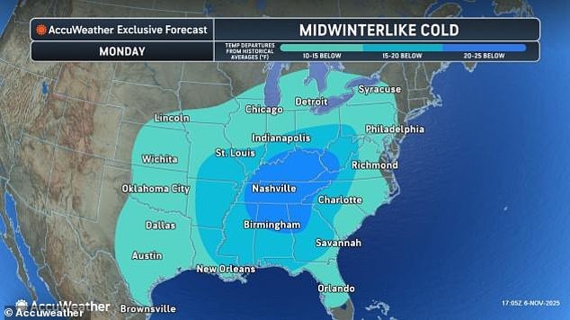
By Monday, the interior Southeast is expected to experience some of the most extreme deviations during this cold outbreak, with temperatures running 15 to 25 degrees below the seasonal average
These areas could see several inches of snow through Tuesday, enough to make roads slushy and slippery, particularly at night. Commuters should keep this in mind for Monday and Tuesday travel in these regions.
However, more of the US will be blasted by Arctic air than snow in the coming days.
Meteorologists say this pattern allows temperatures to drop 10 to 20 degrees below average, stretching all the way from the northern Plains down into the Gulf Coast states.
For some areas, the daytime high will barely reach what is normally the overnight low, creating a prolonged period of frigid conditions for residents.
In Tallahassee, Florida, the high will be 56 degrees above freezing, but still well below seasonal norms, with the average low sitting at 49 degrees.
Meanwhile, temperatures farther inland will plunge below freezing, with forecasts showing Tallahassee dropping to 30 degrees and Jackson, Mississippi, near 27 degrees early next week.
In Southwest Florida, a strong cold front is expected to move through Naples on Monday and Tuesday, producing record-like temperatures and winds exceeding 30 mph.
Highs and lows are projected to sit 15 to 20 degrees below average, with early morning lows dipping into the 40s, a rare occurrence for this subtropical region.

In Tallahassee, Florida, the high will be 56 degrees above freezing, but still well below seasonal norms, with the average low sitting at 49 degrees
The cold may have some unusual side effects, as temperatures dip below 50 degrees, local iguanas are expected to stiffen and literally fall from trees, a phenomenon that has become a seasonal spectacle in Southwest Florida.
Residents in the region often collect the lizards for food or disposal, but this year’s Arctic blast could make the phenomenon more widespread and unpredictable.
The first wave of cold air will arrive with and just behind a fast-moving storm system called an Alberta Clipper, which is originating from southwestern Canada.
These systems are known for bringing quick bursts of cold air, snow, and gusty winds as they race across the continent.
Behind the storm, the Arctic air will continue to march eastward, reaching the Southeast and Mid-Atlantic states by early next week.
Meteorologists caution that the extended period of frigid conditions could cause frozen pipes, power strain, and travel disruptions.
Snowfall is also expected across parts of the northern US, including the Midwest and Northeast.
While the southern Plains and Southeast will mainly see freezes, northern cities are likely to witness the first measurable snow of the season, adding another layer of complexity for commuters and local authorities preparing for the early winter conditions.
Experts are urging residents to bundle up, protect vulnerable plants and animals, and prepare for potential disruptions.